Spatio-Temporal Rainfall Forecasting & Vulnerability Mapping System
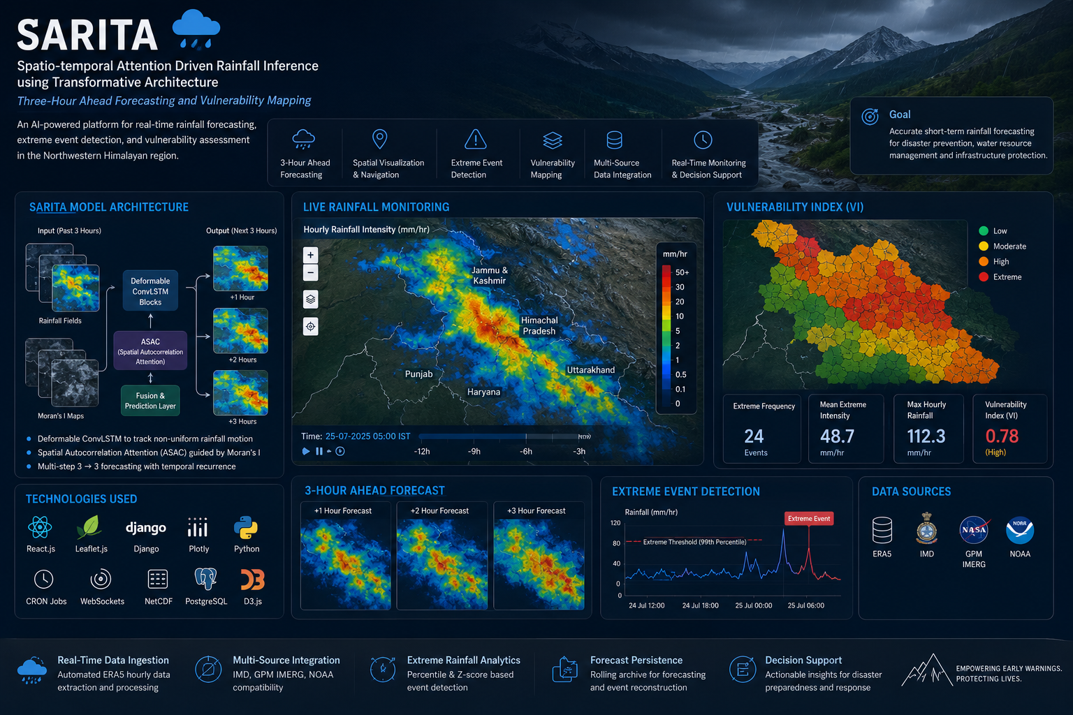
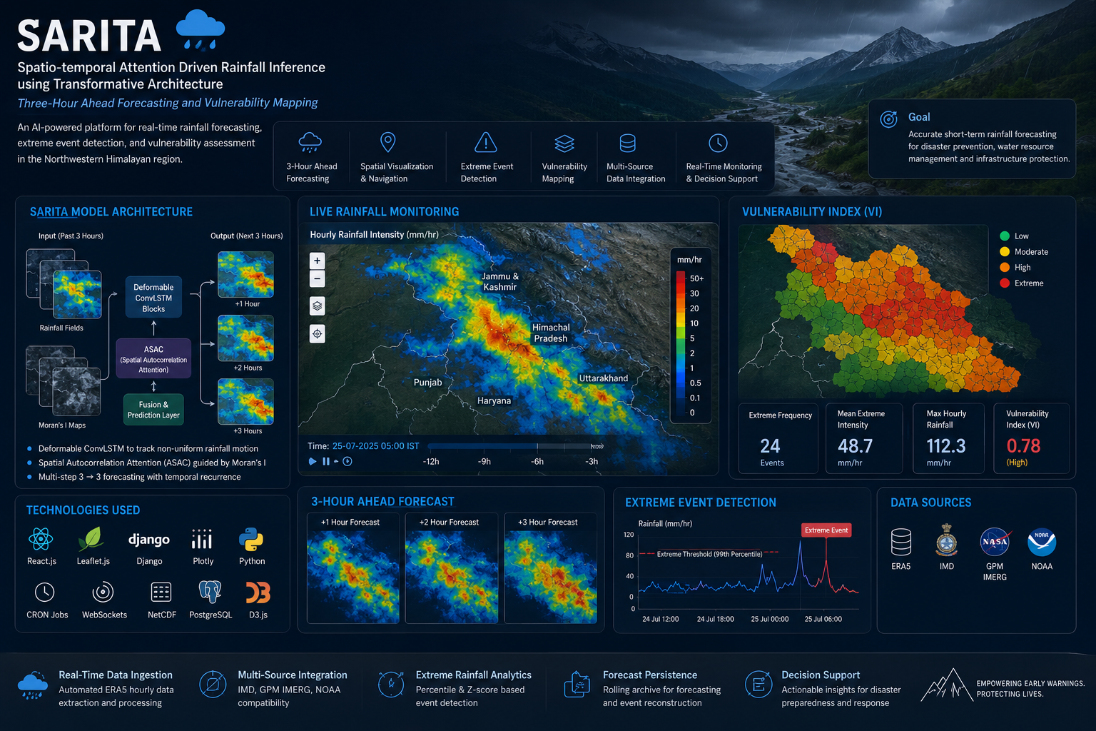
AI-Driven Extreme Rainfall Forecasting and Disaster Intelligence for the Northwestern Himalayas Developed an advanced real-time rainfall forecasting and vulnerability analysis platform using the SARITA (Spatio-temporal Attention driven Rainfall Inference using Transformative Architecture) model. The system predicts rainfall patterns up to 3 hours ahead and provides interactive spatial visualization, anomaly detection, and vulnerability mapping for the Northwestern Himalayan region.
Technologies Used
Transformer-based Attention ArchitectureConvLSTMNetCDF ProcessingSpatial AnalyticsPythonPandasNumPyHugging Face
Project Details
 Project Overview:
The project focuses on improving short-term rainfall forecasting in complex Himalayan terrain using transformer-based spatio-temporal deep learning techniques. The system integrates automated ERA5 weather data ingestion, attention-based forecasting architecture, and interactive GIS dashboards to support disaster prevention, flood monitoring, and hydrological decision-making.
Core Functionalities:
(i)Real-time rainfall forecasting using SARITA architecture
(ii)Spatio-temporal attention-based rainfall inference
(iii)Automated ERA5 precipitation data ingestion
(iv)Interactive GIS rainfall heatmaps and spatial navigation
(v)Extreme rainfall detection using percentile and z-score analysis
(vi)Vulnerability Index (VI) computation and visualization
(vii)Multi-source weather data compatibility (IMD, NOAA, GPM IMERG)
(viii)Forecast archival and hydrological event reconstruction
Technology Stack:
Frontend: React.js, Leaflet.js, Plotly, D3.js
Backend: Django, REST APIs, CRON Jobs, WebSockets
Machine Learning & AI: Transformer-based Attention Architecture, ConvLSTM
Data Sources: ERA5, NOAA, GPM IMERG, IMD
Programming & Processing: Python, NetCDF Processing, Spatial Analytics
SARITA Model Architecture
The SARITA framework combines:
Deformable ConvLSTM Blocks for modeling non-uniform rainfall motion
Spatial Autocorrelation Attention (ASAC) guided by Moran’s I
Multi-step 3→3 Forecasting Strategy for short-range rainfall prediction
This architecture enables the model to capture dynamic rainfall propagation patterns across neighboring geographic regions with high temporal precision.
Dashboard Capabilities:
Real-time rainfall heatmaps with GIS overlays
Temporal rainfall replay and spatial navigation
Vulnerability layer visualization with color-coded risk levels
Extreme event analytics and threshold detection
Multi-region flood monitoring and comparison
Automated forecast persistence and archival system
Case Study: 2025 Uttarkashi Flash Flood
Performed a detailed hydrometeorological analysis of the 2025 Uttarkashi Flash Flood using hourly ERA5 rainfall data. The study identified a strong spatio-temporal linkage between upstream Dharali rainfall and downstream Uttarkashi flood conditions with an approximate 6-hour lag correlation.
Key Findings:
Detected extreme rainfall bursts preceding the flood event
Identified upstream-to-downstream rainfall propagation patterns
Demonstrated the importance of sub-6-hour forecasting capability
Validated SARITA’s effectiveness for early warning systems in mountainous terrain
Key Achievements
Built a real-time AI-powered rainfall intelligence platform
Developed automated weather data ingestion and monitoring pipelines
Enabled high-resolution rainfall forecasting for disaster preparedness
Improved extreme weather analysis and vulnerability assessment
Integrated predictive analytics with interactive GIS visualization
Domain:
Artificial Intelligence | Deep Learning | Climate Analytics | Disaster Management | Geospatial Intelligence